Plaats:Ittervoort:1866:1: verschil tussen versies
Geen bewerkingssamenvatting |
Geen bewerkingssamenvatting |
||
| Regel 5: | Regel 5: | ||
|afbeelding_groot=https://imsr.ghklandvanthorn.nl/i/Qlikeog.jpg | |afbeelding_groot=https://imsr.ghklandvanthorn.nl/i/Qlikeog.jpg | ||
|cartograaf=Jacob Kuyper (1821-1908) | |cartograaf=Jacob Kuyper (1821-1908) | ||
|archiefstuk= | |archiefstuk=Qlikeog.jpg | ||
|deelarchief_url=https://www.atlas1868.nl/ | |deelarchief_url=https://www.atlas1868.nl/ | ||
|deelarchief=Gemeente Atlas Nederland 1868 | |deelarchief=Gemeente Atlas Nederland 1868 | ||
Versie van 31 jul 2024 12:28

Terug naar Historische kaarten
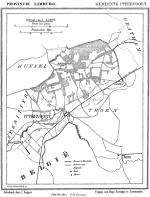
Impressum 1866 1866 - Gemeente Ittervoort
Cartograaf Jacob Kuyper (1821-1908)
Kaart afkomstig uit Gemeente Atlas Nederland 1868 aanwezig in atlas1868