Cartograaf:Jacob Kuyper (1821-1908): verschil tussen versies
Geen bewerkingssamenvatting |
Geen bewerkingssamenvatting |
||
| Regel 2: | Regel 2: | ||
|geboortedatum=1821 | |geboortedatum=1821 | ||
|overlijdensdatum=1908 | |overlijdensdatum=1908 | ||
|afbeelding=https:// | |afbeelding=https://i.imgur.com/VrYnvAp.jpg | ||
|kaart={{#tag:easyview|{{e1}}kmz/cartografen/Jacob_Kuyper_(1821-1908).kmz|lat=51.998252|lon=4.405386|type=map|zoom=9|height=270}} | |kaart={{#tag:easyview|{{e1}}kmz/cartografen/Jacob_Kuyper_(1821-1908).kmz|lat=51.998252|lon=4.405386|type=map|zoom=9|height=270}} | ||
|link=sjabloon:{{sys:titeldeel}}:link | |link=sjabloon:{{sys:titeldeel}}:link | ||
| Regel 8: | Regel 8: | ||
|semantic:naam=Kuyper, Jacob (1821-1908) | |semantic:naam=Kuyper, Jacob (1821-1908) | ||
|semantic:naam:volledig=Jacob Kuyper (1821-1908) | |semantic:naam:volledig=Jacob Kuyper (1821-1908) | ||
|semantic:afbeelding=https:// | |semantic:afbeelding=https://i.imgur.com/VrYnvApt.jpg | ||
}}{{sys:terug|pagina=Historische kaarten}} | }}{{sys:terug|pagina=Historische kaarten}} | ||
<br> | <br> | ||
{{sys:kaart:tijdslijn|kop=Historische kaarten|categorie=Cartograaf:{{sys:titeldeel}}|height=650|navigationheight=400|limiet=52}}{{sys:kaart:overzicht|categorie=Cartograaf:{{sys:titeldeel}}}} | {{sys:kaart:tijdslijn|kop=Historische kaarten|categorie=Cartograaf:{{sys:titeldeel}}|height=650|navigationheight=400|limiet=52}}{{sys:kaart:overzicht|categorie=Cartograaf:{{sys:titeldeel}}}} | ||
Versie van 24 nov 2022 18:58

|
| Externe links |
Terug naar Historische kaarten
Historische kaarten
Impressum 1866 1866 - Gemeente Baexem
Cartograaf Jacob Kuyper (1821-1908)
Kaart afkomstig uit Gemeente Atlas Nederland 1868 aanwezig in atlas1868Impressum 1866 1866 - Gemeente Beegden
Cartograaf Jacob Kuyper (1821-1908)
Kaart afkomstig uit Gemeente Atlas Nederland 1868 aanwezig in atlas1868Impressum 1866 1866 - Gemeente Heel en Panheel
Cartograaf Jacob Kuyper (1821-1908)
Kaart afkomstig uit Gemeente Atlas Nederland 1868 aanwezig in atlas1868Impressum 1866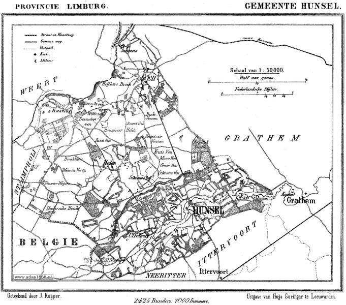 1866 - Gemeente Hunsel
Cartograaf Jacob Kuyper (1821-1908)
Kaart afkomstig uit Gemeente Atlas Nederland 1868 aanwezig in atlas1868Impressum 1866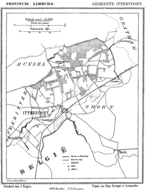 1866 - Gemeente Ittervoort
Cartograaf Jacob Kuyper (1821-1908)
Kaart afkomstig uit Gemeente Atlas Nederland 1868 aanwezig in atlas1868Impressum 1866 1866 - Gemeente Neeritter
Cartograaf Jacob Kuyper (1821-1908)
Kaart afkomstig van < Gemeente Atlas Nederland 1868>Impressum 1866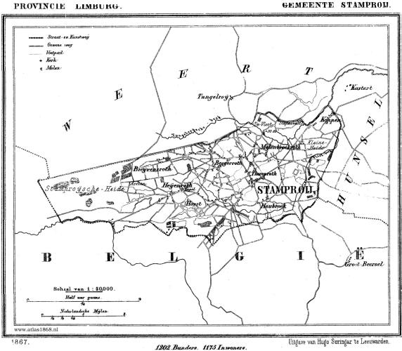 1866 - Gemeente Stramproy
Cartograaf Jacob Kuyper (1821-1908)
Kaart afkomstig uit Gemeente Atlas Nederland 1868 aanwezig in atlas1868Impressum 1866 1866 - Gemeente Wessem
Cartograaf Jacob Kuyper (1821-1908)
Kaart afkomstig uit Gemeente Atlas Nederland 1868 aanwezig in atlas1868Impressum 1867 1867 - Gemeente Thorn
Cartograaf Jacob Kuyper (1821-1908)
Kaart afkomstig uit Gemeente Atlas Nederland 1868 aanwezig in atlas1868Impressum 1867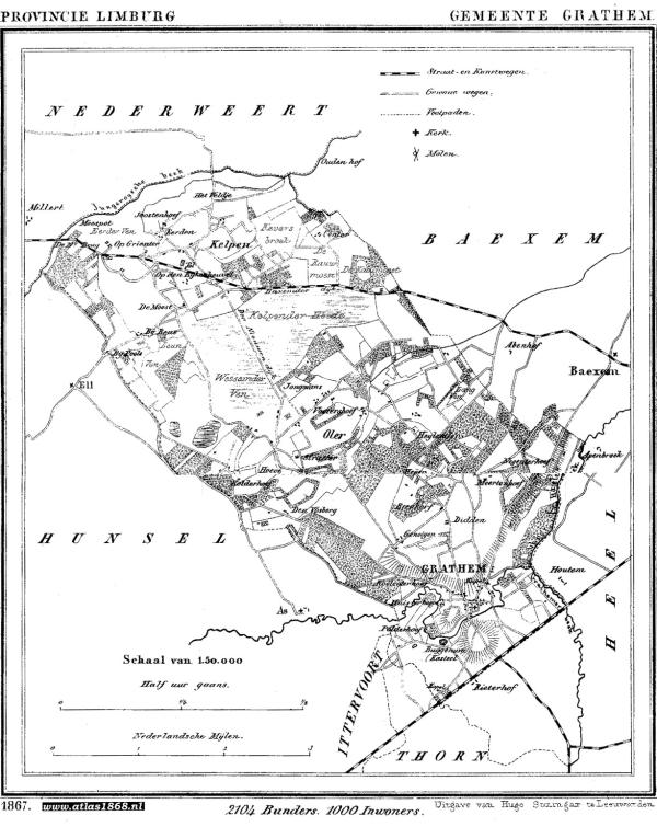 1867 - Grathem
Cartograaf Jacob Kuyper (1821-1908)
Kaart afkomstig uit Gemeente Atlas Nederland 1868 aanwezig in atlas1868